A Subduction Zone Caught in the Act of Dying
SCIENCE & TECHNOLOGY · SEPTEMBER 26, 2026
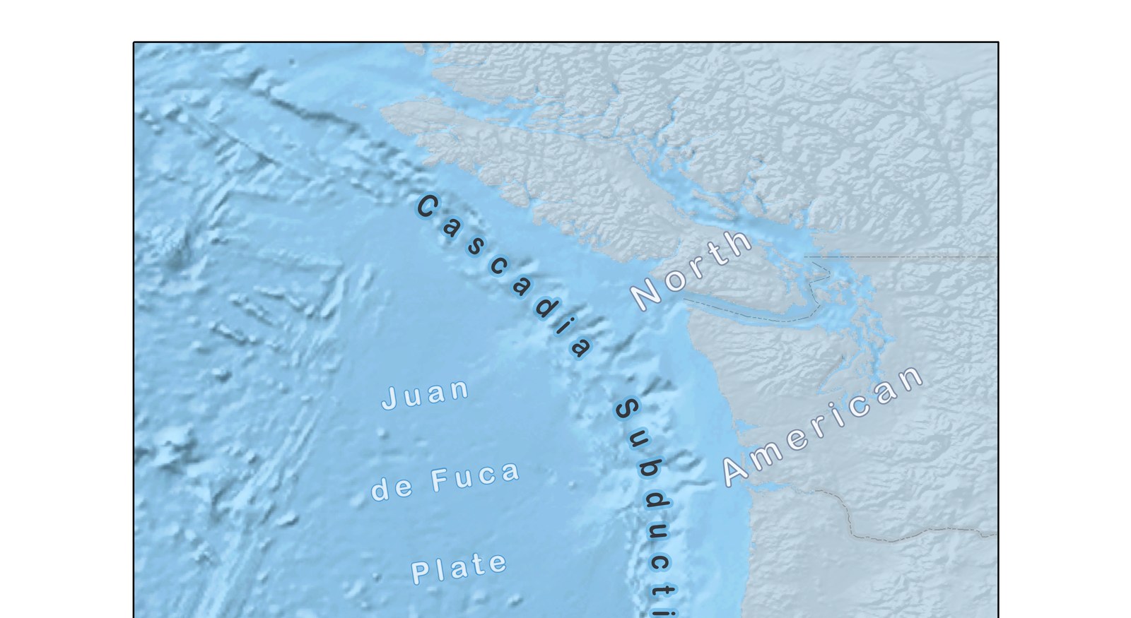
A team led by Brandon Shuck, a marine geophysicist at Louisiana State University, has imaged a tear actively opening in the seafloor off northern Vancouver Island, in a paper published this week in Science Advances. The tear sits in the Nootka Fault Zone, the roughly 75-kilometre-long boundary between the Juan de Fuca Plate and the smaller Explorer Plate to its north — both pieces of the same oceanic crust that's been sliding under North America along the Cascadia subduction zone. Along one section of that boundary, the researchers traced a specific slab tear extending about 35 kilometres (22 miles), across which the subducting plate has already dropped roughly 5 kilometres relative to its neighboring section. Shuck's read on what that means is blunt: "This is the first time we have a clear picture of a subduction zone caught in the act of dying."
What the Nootka Fault Zone Actually Separates
Cascadia's subduction zone is usually described as one continuous system — the Juan de Fuca Plate diving under North America along roughly 1,000 kilometres of coastline, from northern California to Vancouver Island, building the pressure that will eventually produce a magnitude-8.5-to-9 megathrust earthquake. But that single-plate picture breaks down at its northern end. There, the Juan de Fuca Plate meets the much smaller Explorer Plate, and the boundary between them — the Nootka Fault Zone — sits inside one of the more crowded intersections in plate tectonics: the Pacific, North American, Juan de Fuca and Explorer plates all converge within about 300 kilometres of each other. Shuck's team argues the Explorer Plate isn't really keeping pace with its neighbor anymore. It's being peeled away, and the Nootka Fault Zone is where that separation is happening.
How You Image a Tear 5 Kilometres Down
The data behind this comes from the 2021 Cascadia Seismic Imaging Experiment (CASIE21), which used the research vessel Marcus G. Langseth towing a 15-kilometre hydrophone streamer — a long cable of listening sensors — behind an array of air guns. The air guns fire sound waves into the seafloor; the streamer records the echoes bouncing back off buried rock boundaries, the same principle sonar uses to find a submarine, just aimed straight down through kilometres of crust. Layered against decades of earthquake records from the region, that seismic-reflection imaging let Shuck's team trace out a broad shear zone that first started forming about 4 million years ago, when a change in the seafloor-spreading ridge geometry set the stage, and has since narrowed into what the paper calls a mature, trench-perpendicular transform boundary roughly 19 kilometres (12 miles) wide. Within that corridor, the tears run parallel to the trench but offset from one another — evidence, the authors argue, that the rip has been propagating sideways along the boundary rather than opening everywhere at once.
This isn't the earthquake fault people worry about. The megathrust that would produce Cascadia's "Really Big One" is the shallow, locked interface between the Juan de Fuca Plate and North America, further south and much closer to the coast. The Nootka Fault Zone tear is a separate structure, inside the subducting slab itself, at the plate's northern edge — Shuck's team notes that a detached section of crust there could act as a partial barrier to future rupture, potentially slowing or redirecting it, rather than making a bigger earthquake more likely.
Why "Piece by Piece" Is the Interesting Part
The standard mental model for a subduction zone ending is that it just stops — the plate finishes sliding under, the two sides weld together, done. Shuck's paper argues for something messier: subduction zones can wind down the way old bridges get decommissioned, one span closed at a time rather than the whole structure dropped at once. "Rather than shutting down all at once, the plate is ripping apart piece by piece, creating smaller microplates and new boundaries," Shuck said — elsewhere reportedly likening it to watching a train derail one car at a time. That's not a new idea in the abstract — geologists have long known that the ancient Farallon Plate, which used to subduct along most of the West Coast, left behind fossil microplates off Baja California when it broke up tens of millions of years ago. What's new here is catching the process mid-stride, at a subduction zone that's still very much active, instead of reading it backward from the wreckage.
Where I Could Be Wrong
I couldn't get past the paywall on the Science Advances paper itself (the publisher's site returned an access error when I tried), so everything here about the interpretation — the "4 million years," the exact width of the transform corridor, the tear-propagation argument — is drawn from the paper's own abstract language as relayed by science journalism covering it, not from reading the seismic sections and methods myself. One quote attributed to Shuck, about the process resembling a train derailing one car at a time, comes from a single secondary write-up rather than something I could verify against a primary transcript or the paper's own text, so I've flagged it as a paraphrase rather than treated it as a precise quotation. And "caught in the act of dying" is a vivid framing from the lead author, not a peer-reviewed conclusion in itself — the underlying seismic evidence (the tear, the offset, the shear zone's age) is the solid part; how definitively that adds up to a subduction zone's death, versus one plausible read of a genuinely messy boundary, is the part I'd want a second independent group to weigh in on before treating it as settled.
Sources
- Shuck, B. et al. Slab tearing and segmented subduction termination driven by transform tectonics. Science Advances, September 2026. DOI: 10.1126/sciadv.ady8347
- ScienceDaily. Earth is tearing apart beneath the Pacific Northwest. September 2026. sciencedaily.com
- Earth.com. Earth's crust is breaking apart off the Pacific coast. September 2026. earth.com
- The Watchers. Scientists image a massive rupture developing beneath northern Cascadia. September 2026. watchers.news
- U.S. Geological Survey. Cascadia Subduction Zone Database. usgs.gov